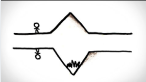
Here’s a high plateau on mars, rising up above the surrounding landscape.
这是火星上的高原,高耸于周围的景观之上。
Or… is it a system of valleys and canyonlands cut into the surrounding plains?
或者,它是一个割裂周围平原的山谷和峡谷系统吗?
And here’s another – is this text/image cut into the wood, or is it bumping out?
这是另一个——这个文本/图像是凹进木头里的,还是凸出来的?

Like the famous duck/rabbit illusion, it can sometimes be hard to perceive both sides of these illusions, so let’s try one more: a series of plateaus on earth? Or the grand canyon?
就像著名的鸭子/兔子错觉一样,有时很难同时理解这两种错觉,所以让我们再试一个:地球上的一系列高原? 或者大峡谷?
So why do we sometimes see these features as popping up or out of the image, and why do we sometimes see them as cut or dented in?
那么,为什么我们有时会看到这些特征突然出现或从图像中消失,为什么我们有时会看到它们被切割或凹进去?
There are essentially two reasons: First, the fact that on earth the sun is always overhead, and second, a weird symmetry of light and shadows.
基本上有两个原因:第一,地球上的太阳总是在头顶上,第二,光和影的奇怪对称。
Ok, so if you’re a human who grew up on earth, you’re used to the fact that light mostly comes from above.
好吧,如果你是在地球上长大的人,你已经习惯了光线主要来自上方的事实。
I mean, the sun is always overhead, illuminating things from above, or above and to the side, but never from below the horizon, which means that shadows are pretty much always on the bottoms of things.
我的意思是,太阳总是在头顶上,从上方或侧面照亮事物,但从不从地平线以下,这意味着阴影几乎总是在事物的底部。
This is so ingrained in us and our culture that religion talks about falling down into darkness and being raised up into the light, western art exhibits a “top-left lighting” convention,
这在我们和我们的文化中是如此根深蒂固,以至于宗教谈论堕入黑暗中,并被上升到光明中,西方艺术展示了一种“左上角照明”的惯例,
as does computer interface design, and the international space station has lights on one side to help give floating astronauts a consistent sense of “up” and “down”.
正如计算机界面设计一样,国际空间站的一侧有灯光,以帮助漂浮的宇航员有一种一致的“上”和“下”的感觉。
And “Shadows on the bottom, light on the top” gives our brains a way to perceive the 3D-ness of features just from the position of their shadows.
“阴影在底,光线在上”让我们的大脑通过阴影的位置来感知特征的三维性。
If there’s a bump sticking out from a wall, the shadow will be on the bottom of the bump.
如果有一个凸起从墙上伸出来,阴影就会在凸起的底部。
If there’s a dent in the wall, the shadow will be on the bottom of the overhang, which means the TOP of the dent.
如果墙上有凹痕,影子会在凸出物的底部,也就是凹痕的顶部。
Roughly speaking, when we have no other context and see shadows on the bottom of a feature, we perceive it as convex, coming towards us, and when we see shadows on the top of a feature, we perceive it as concave, or dented away.
粗略地说,当我们在没有其他背景的情况下看到一个特征底部的阴影时,我们会认为它是向我们走来的凸面,而当我们看到特征顶部的阴影时,我们会认为它是凹的,或者说凹进去了。
But there’s a cruel symmetry in nature: a concave feature, lit from one side, can cast very similar shadows to its convex counterpart, lit from the other side.
但在本质上有一种残酷的对称:一个凹面,从一边被照亮,可以投射出非常相似的阴影,它对应的凸面,从另一边被照亮。
A bump lit from above has shadows on the bottom, and a dent lit from below also has shadows on the bottom, which makes it easy to misperceive a dent lit from below as a bump, or a bump lit from below as a dent.
从上面点燃的凸起在底部有阴影,从下面点燃的凹痕在底部也有阴影,这很容易把从下面点燃的凹痕误认为是凸起,或从下面点燃的凸起误认为是凹痕。
Similarly, a mountain range lit from the east has shadows on its western slopes, while a valley lit from the west also has shadows on its western slopes.
同样地,从东边照亮的山脉在其西坡上有阴影,而从西边照亮的山谷在其西坡上也有阴影。
Not really a problem when you’re standing next to the mountain or valley.
当你站在山或谷旁边时,这并不是一个问题。
But viewed from high enough above, all our brains really have to go on for the concavity or convexity of landscape features is their shadows.
但从足够高的角度看,我们所有的大脑都不得不继续思考,因为地形特征的凹凸是它们的阴影。
So we’ll tend to see these geographic features as mountains when the shadows are on the bottom, and valleys when shadows are on the top.
所以当阴影在底部时,我们倾向于把这些地理特征看作山,当阴影在顶部时,我们倾向于把这些地理特征看作谷。
Which, of course, is only correct if the light happens to be coming from the top of the image.
当然,只有当光线恰好来自图像上方时,这种方法才正确。
In fact, the mountain or valley illusion is so strong that shaded relief maps of the northern hemisphere generally show light coming from the north, a direction the sun never actually shines in most of those places.
事实上,山或谷错觉是如此强烈,以至于北半球的阴影地形图通常显示光线来自北方,而在这些地方的大多数地方,太阳实际上从来不会照到这个方向。
Cartographers are more than willing to sacrifice the accuracy of the sun’s position to ensure that they accurately communicate the geographic features they’re mapping.
制图师更愿意牺牲太阳位置的准确性,以确保他们准确地传达他们绘制的地理特征。
And it’s good they do – I actually decided to make this video after I was looking at a map upside down from across a table, and my brain thought that all the valleys were mountains and mountains were valleys!
它们这样做很好——我决定做这个视频是因为我在桌子对面看一张倒过来的地图,我的大脑认为所有的谷都是山,山都是谷!
I had to get up, clear my head and go around to the other side of the table before I could get them to switch to being the right way round.
我必须站起来,清醒一下头脑,绕到桌子的另一边,才能让他们转到正确的位置。
So if you’re confused why a map or aerial or satellite photo looks weird, try rotating it 180° to see if it makes more sense!
所以,如果你对地图、航空照片或卫星照片看起来很奇怪感到困惑,可以尝试将其旋转180°,看看是否更有意义!


